 Aero Academic
Aero Academic
Aero Academic
The quickest way to learn ERSA is to read real entries side by side. Perth is a large certified airport with an instrument runway system and a 24 hour fire service. Jandakot is a busy certified training aerodrome with a tower that closes, pilot activated lighting and local circuit rules. This guide walks each block in order and shows what changes.
Checked against: ERSA aerodrome entries for Perth (YPPH) and Perth/Jandakot (YPJT), effective 26 NOV 2026 (published ahead of that date). Figures are examples for learning only; always read the current entry.
| Question | Perth (YPPH) | Perth/Jandakot (YPJT) |
|---|---|---|
| Classification | CERT, certified aerodrome | CERT, certified aerodrome |
| Elevation and variation | 67 ft; variation 2 degrees west | 99 ft; variation 2 degrees west |
| Local time | UTC plus 8 (Western Standard Time) | UTC plus 8 (Western Standard Time) |
| Runways | Two crossing runways, 03/21 and 06/24, with pavement strength in PCR form and a grooved surface noted on 03/21 | Three runways: a parallel pair 06L/24R and 06R/24L, and 12/30, each with strength coded F/A/Y/T and a 90 m strip |
| Runway lighting | High and medium intensity runway lights, centre line lights on 03/21, PAPI, high intensity approach lights, standby power on the main runway | Medium intensity runway lights, PAPI on 24R, pilot activated lighting with audio acknowledgement, automatic standby power |
| Instrument aids | ILS and DME for several runway ends, VOR/DME | A pilot-monitored NDB only |
| Rescue and firefighting | Category 9, H24 | No category printed in the entry |
| Weather information | TAF category A, METAR/SPECI, aerodrome and wind shear warnings, AWIS | TAF category B, METAR/SPECI, aerodrome warnings, AWIS |
| What happens when the tower is closed | The entry we read lists a tower, approach and ATIS, with notes on which frequency to call for clearances; check the entry for hours | Airspace becomes Class G; PAL is available outside tower hours; a flight information service frequency applies |
| Local rules | Special procedures section; hot spots marked on the aerodrome diagram | Start approval for fixed-wing circuit training in tower hours; circuit height and direction rules; run-up bay limits |
Everything here is an example drawn from one edition. Frequencies, hours, fees and procedures change. Treat the values in this guide as illustrations of how to read, and read the entry in the edition in force on the day you fly. The ERSA is published ahead of its effective date, so look at the date on the page header as well as the cover.
We deliberately do not copy the entries into this guide. ERSA is Airservices Australia copyright, and our job is to teach you how to read it, not to replace it. Open the real pages next to this guide so you can follow along.
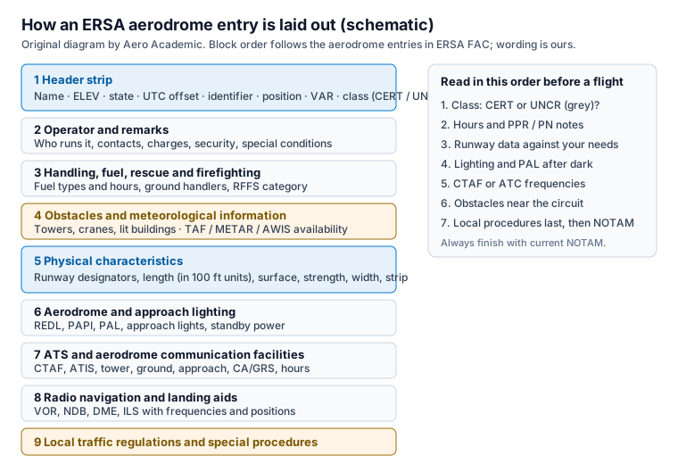
Both entries start with the place name, the elevation, an AVFAX code, the state, the UTC offset, the location identifier, the aerodrome reference point position, the magnetic variation and the classification. Perth shows an elevation of 67 feet and Jandakot shows 99 feet. Both are certified, both are on Western Standard Time, which is UTC plus 8, and both show variation of two degrees west.
Notice what you can conclude without reading further. Certified means full information is published and a full NOTAM service applies. UTC plus 8 means local standard time is eight hours ahead of UTC, and Western Australia does not observe daylight saving in the way the eastern states do, so a published UTC hour converts by adding eight. Variation of two degrees west means a magnetic bearing is the true bearing plus two degrees.
After the header comes the aerodrome operator with a postal address, email, phone number and an aerodrome reporting officer contact. This tells you who to call for information that is not published. Perth also carries remarks that all aircraft are charged and that the airport is a security controlled airport, plus a follow-me service on request to ATC.
Jandakot carries a different set of remarks: visitor airside access is arranged through the operator, charges follow the operator schedule, the aerodrome is not available to aircraft above 5,700 kg maximum take-off mass without prior permission, aircraft with a wingspan over 15 metres that need parking require prior permission, and there is no lit itinerant parking.
Remarks like these are where operational surprises hide. A pilot of a heavier or larger aeroplane who skips the remarks would arrive at a field that has said no without permission. The lesson is to read every numbered remark, not only the runway data.
Handling services list fuel suppliers, fuel types and hours, ground handlers and what they provide. Perth lists several suppliers, jet fuel, and handlers for general aviation, and it says general aviation and itinerant operators must appoint a ground handling agent 48 hours before operating. Jandakot lists two suppliers with aviation gasoline and jet fuel and card arrangements, with notes on after-hours availability.
Perth also shows a rescue and firefighting category, category 9, available at all hours, with a frequency. That category matters to operators of larger aircraft. At Jandakot the entry we read does not print a category, which tells you that you should not assume a fire service for your arrival. If your operation needs one, confirm with the operator.
The obstacle list gives positions, heights above mean sea level, bearings and distances from the aerodrome reference point, and whether each is lit or marked. Perth lists many tall structures, including a control tower, broadcast towers and buildings in the city, plus items that infringe the take-off climb surface. Jandakot lists a lit tower and an unlit power pole, each with a bearing and distance.
When you read the obstacle list, ask whether anything lies on your departure or arrival path and whether it is lit. An unlit pole at night is the type of detail you want to know about before you take off, not after. The meteorological block tells you what weather services exist: the TAF category, whether METAR and SPECI are issued, aerodrome and wind shear warnings, and the automatic weather information service.
Runway data is printed as designators, a length in hundreds of feet with a surface code, a pavement strength code, the width and the strip width. Perth shows two runways with a pavement rating in PCR format and a grooved surface note. Jandakot shows three runways with strength coded F/A/Y/T, widths of 30 metres on the two longer runways and 18 metres on the shorter parallel, and a 90 metre strip.
Do the comparison against your aircraft. The numbers here are screening data. Take-off and landing distances come from your flight manual and the declared distances, adjusted for slope, surface, wind and temperature. The strength code only matters if your aircraft is heavy enough to approach the limit.
Perth lists high intensity and medium intensity runway lights, centre line lights on the main runway, PAPI with a 3.0 degree slope and a minimum eye height at the threshold, high intensity approach lighting for the instrument runway ends and touchdown zone lights on one runway. Standby power is noted against the main runway lines.
Jandakot lists medium intensity runway lights, a PAPI on runway 24R, and pilot activated lighting with audio acknowledgement on a frequency. A footnote says the PAPI is activated by PAL outside tower hours and on request to ATC during tower hours. The other lighting note says standby power switches over automatically in about 15 seconds. That delay is worth knowing: after a power failure the lights go out briefly.
Perth lists an approach service, an ATIS and a tower with frequencies, with footnotes explaining who to call for clearances and how to get ATIS by telephone. Jandakot lists a flight information service from the centre when the tower is closed, an ATIS, a ground frequency and a tower with two frequencies, with seasonal tower hours and a statement of what airspace applies.
The key sentence at Jandakot is the one about airspace: the tower provides air traffic services within Class D airspace from the surface to 1,500 feet during tower hours, and outside tower hours the airspace becomes Class G. That changes how you call, what you can expect and who separates you from other aircraft. If your plan puts you near the tower closing time, work out which side of that line you will be on.
Perth shows ILS, glide path, localiser and DME facilities for several runway ends with positions, frequencies and notes about antenna elevation and threshold crossing height, plus a VOR/DME. Jandakot shows a single NDB marked as pilot monitored, meaning you must monitor it yourself.
Local traffic regulations and flight procedures are where training aerodromes differ most. Jandakot requires start approval for fixed-wing aircraft doing circuit training during tower hours, sets a circuit altitude of 1,000 feet with 800 feet for helicopters remaining north of the main runway, and has rules about simulated engine failure after take-off, practice approaches and run-up bays. If you read only one block at a training field, read this one.
Three habits come out of reading these entries side by side. First, always begin with the classification and the remarks, because they can rule you out before you read the runways. Second, always find what changes when a service closes, because tower hours and airspace class often change together. Third, read the local procedures even when the runway data looks simple, because a short numbered rule can matter more than a long table.
They are close together but very different. One is a large airport with instrument aids and a 24 hour fire service. The other is a busy training aerodrome with a tower that closes and local circuit rules. The contrast shows what each block of an entry is for.
No. They are examples from one edition. Use the ERSA, NOTAM and the operator for current information on the day you fly.
The entry says the airspace becomes Class G outside tower hours, a flight information service applies and pilot activated lighting is available. Read the entry for the frequencies and procedure.
It means the aid is not monitored by a ground station, so the pilot should monitor its identification and signal.
So you can judge whether a tower, pole or building affects your take-off, climb-out or approach, and whether it is lit at night.
https://www.aeroacademic.com.au/guides/ersa-walkthrough-perth-and-jandakot