 Aero Academic
Aero Academic
Aero Academic
ERSA, the En Route Supplement Australia, is the Airservices Australia book that lists every published aerodrome and navigation facility with its runways, lighting, radio frequencies, services, hazards and local rules. It is part of the Aeronautical Information Package, reissued on a 13 week cycle, and you read it before every flight to an unfamiliar field.
Checked against: ERSA effective 26 NOV 2026, published ahead of that date (Introduction and Facilities directory) and AIP Australia Amendment 129 (GEN 3.1, AD 1.1), both published by Airservices Australia.
| You want to know | Look in | Why |
|---|---|---|
| Runway length, surface, lighting, fuel, CTAF at a particular aerodrome | ERSA (aerodrome entry) | ERSA is the aerodrome directory. AIP AD 1.1 says the directory is published as ERSA. |
| The instrument approach or departure procedure for an aerodrome | DAP (Departure and Approach Procedures) | DAP carries the terminal procedure charts. ERSA points you to them under “charts related to the aerodrome”. |
| Rules, definitions and abbreviations that apply nationally | AIP Book (GEN, ENR, AD) | The AIP Book is the basic document for permanent information. |
| A runway closure, a temporary hazard, a navaid outage | NOTAM | NOTAM carries information of direct operational significance that cannot wait for the next cycle. |
| A long-running temporary change with extensive text or graphics | AIP Supplement (SUP) | Used for temporary changes of three months or longer. |
| Controlled airspace dimensions and designations | Designated Airspace Handbook (DAH) and charts | Airspace is published separately from the aerodrome directory. |
ERSA is published by Airservices Australia, the same organisation that runs air traffic services and the aeronautical information service. It is not a CASA publication, and it is not a training book. It is an operational reference that pilots, operators and flight planners use every day.
The AIP Book describes where ERSA fits. In GEN 3.1 the Aeronautical Information Publication Australia is listed as made up of the AIP Book, Departure and Approach Procedures (DAP), the En Route Supplement Australia (ERSA), the Designated Airspace Handbook (DAH) and maps and charts. So ERSA is one of the volumes of the AIP, in the same family as the DAP and the charts you already use.
The ERSA Introduction states that ERSA is issued on a 13 week cycle, with amendments for military users every four weeks. Because it is reissued on a fixed cycle, the printed or downloaded edition has an effective date on every page. Check that date before you rely on a figure. The edition used to check this guide is effective 26 November 2026.
The ERSA Introduction describes the Aerodrome and Facility Directory as listing, alphabetically, the details of aerodromes, navigation aids, air traffic services, ground services, public facilities and special procedures. The book opens with a Facilities (FAC) index of aerodromes, a quick-reference guide to preflight and post-flight pilot services, and the legend that explains every code you will meet.
The legend pages are the most useful part to study. They explain how names, locations, magnetic variation, time conversion, runway designation, pavement data, lighting, radio navigation aids, CTAF, AFRU and ATS communication facilities are shown. Almost every confusing abbreviation in an aerodrome entry is defined there, and most of them are also defined in AIP GEN 2.2.
After the directory, the entries themselves follow in alphabetical order by place name. Aerodromes with more than one name are usually identified by city and aerodrome name, so Perth and Perth/Jandakot are separate entries and both sit under P.
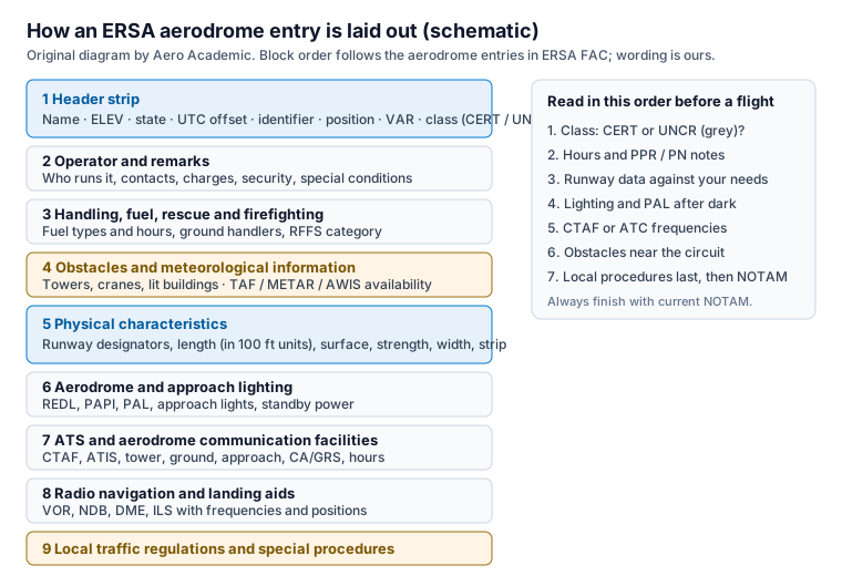
Every entry follows the same pattern, which is why it can be scanned quickly once you know it. Figure 1 shows the blocks in order. The header strip gives the place name, elevation, state, the UTC offset for the local time zone, the location identifier, the aerodrome reference point position, magnetic variation and the classification code. Aerodrome operator contact details and numbered remarks come next.
Below that are the handling services and fuel, the rescue and firefighting category where one applies, the aerodrome obstacles, the meteorological information provided, and the physical characteristics: runway designators, lengths, surfaces, strength, width and strip. Then come aerodrome and approach lighting, the ATS and aerodrome communication facilities, radio navigation and landing aids, and finally the local traffic regulations and any special procedures.
Two details trip up new users. Elevation is the elevation of the highest point of the landing area above mean sea level, in feet, and a minus sign means below sea level. Runway length is the physical length shown in multiples of 100 feet, so a runway between 6,950 and 7,049 feet is printed as 70. Do not read that as 70 feet or 700 metres, and do not use it as a substitute for declared distances when you do performance calculations.
The classification code in the header strip tells you how much weight to put on the page. CERT means a certified aerodrome. MIL means a military aerodrome with prior permission required for civil operations. UNCR means uncertified, and JOINT means a certified civil aerodrome that is also a military aerodrome.
ERSA includes full information for certified and military aerodromes, and these entries are covered by a full NOTAM service. Uncertified aerodromes may appear with limited information and are shown with a grey background. The legend carries a caution on this: information about movement areas and lighting at uncertified aerodromes can change without notice and is not subject to NOTAM action, so the pilot or operator must contact the aerodrome operator to confirm it before flight.
This matters for exam-style thinking as well as for real flying. If a question describes a grey-background entry, the right habit is to treat the printed data as a starting point and to phone the operator. A certified entry is supported by NOTAM, an uncertified one is not.
Pilots often mix these up, so keep the roles straight. The AIP Book holds permanent, national information: definitions, rules, services, airspace structure and the AD section that introduces aerodromes. AIP AD 1.1 states that the aerodrome directory is published as ERSA FAC, listing certified aerodromes with their availability and conditions of use, and that details of uncertified aerodromes and helicopter landing sites are included when the operator asks.
DAP is the volume of terminal procedure charts. ERSA often tells you to refer to it, for example in the entry line that points to Departure and Approach Procedures. NOTAM supplements all of these with information that cannot wait for the next amendment. Table 1 sets the questions against the publication.
The practical rule is to start with ERSA for what an aerodrome is, use DAP for how to arrive or depart on instruments, and finish with NOTAM for what is different today.
A reliable routine keeps you from skipping a block. First confirm the edition date is current. Then find the entry by place name and check the classification. Next read the operator notes and remarks for permission requirements, charges, security status and restrictions such as weight limits or wingspan limits that require prior permission.
Compare the runway data to your aeroplane or helicopter and to the performance you calculated. Check the slope and surface, the width, and the obstacle list, because a tower or crane close to the circuit changes your climb-out plan. If you may arrive after dark, read the lighting block for runway edge lights, a precision approach path indicator and pilot activated lighting.
Finally note the communication entries: CTAF, ATIS, tower, ground or a certified air/ground radio service, with hours. Confirm what the airspace becomes outside tower hours, then check NOTAM and weather. Write the frequencies on your flight log rather than relying on memory.
The most common mistake is trusting a stale edition. ERSA is reissued on a cycle, so a download from months ago may show a closed runway, a changed frequency or a withdrawn service. The second is treating an uncertified entry like a certified one. The third is reading the runway length as the usable length for take-off or landing distance without checking declared distances and the effect of slope, surface and obstacles.
Candidates also confuse the time zone block. Operating hours in ERSA are in UTC unless the entry says otherwise, and the header gives the offset for local standard time. The legend notes that allowance should be made for daylight saving where it applies, so an entry that shows local hours does not move with daylight saving on its own.
Aeronautical information questions reward the habit of knowing where each fact lives. Knowing that ERSA is the aerodrome directory, that CTAF is listed under the CTAF heading, that PAL activation is described in the legend and that uncertified information is not NOTAM-supported will help you reason through scenarios on circuit joining, radio calls and aerodrome selection.
When you review a missed question on circuit procedures or radio at uncontrolled aerodromes, read the matching ERSA legend paragraph and the AIP section it cites, then try the questions again. Aero Academic links its explanations on those topics back to guides like this one so the reading and the practice stay together.
ERSA stands for En Route Supplement Australia. It is the aerodrome and facility directory published by Airservices Australia as part of the Aeronautical Information Package.
No. ERSA is one of the volumes of AIP Australia. The AIP Book holds permanent national rules and tables. ERSA holds the aerodrome and facility entries. AIP AD 1.1 says the aerodrome directory is published as ERSA FAC.
The ERSA Introduction says it is issued on a 13 week cycle, with amendments for military users every four weeks. Always check the effective date printed on the page you are using, and check NOTAM for changes since that date.
A grey background marks an uncertified aerodrome with limited published information. The legend warns that movement area and lighting details at these aerodromes can change without notice and are not subject to NOTAM action, so the pilot must contact the operator.
No. Terminal procedure charts are in the Departure and Approach Procedures (DAP). ERSA entries often refer you to DAP under the charts related to the aerodrome.
Treat it as a screening figure. The length is the physical runway length shown in multiples of 100 feet. Use declared distances, slope, surface and obstacle information for performance calculations.
https://www.aeroacademic.com.au/guides/what-is-ersa-en-route-supplement-australia