 Aero Academic
Aero Academic
Aero Academic
An ERSA entry packs a lot into few characters. The legend at the front of ERSA, and AIP GEN 2.2, define each code. This guide groups the ones you will meet most by purpose: classification, time, runways, lighting, radio and navigation aids, so that you can read an entry line by line without guessing.
Checked against: ERSA Introduction (Aerodromes and Facilities and Legends, INTRO 4 to INTRO 15) effective 26 NOV 2026 (published ahead of that date), and AIP Australia Amendment 129, GEN 2.2.
| Code | Meaning | What it means for you |
|---|---|---|
| CERT | Certified aerodrome | Full information is published and covered by NOTAM. |
| UNCR | Uncertified aerodrome | Limited information, grey background, contact the operator to confirm. |
| MIL | Military aerodrome | Prior permission is needed for civil operations. |
| JOINT | Certified civil and military | Both sets of rules and procedures may apply. |
| H24 | Continuous day and night service | Available at all hours. |
| HJ / HN | Sunrise to sunset / sunset to sunrise | Hours tied to daylight, not to the clock. |
| PPR | Prior permission required | You must get approval before arriving. |
| PN | Prior notice required | You must tell them in advance. It is not the same as permission. |
| O/R | On request | Service is provided when asked for. |
| AH | After hours | Outside the published hours of the service. |
| Item | How ERSA shows it | Common misreading |
|---|---|---|
| Runway designator | Magnetic direction rounded to the nearest 10 degrees, so 03/21 lies close to 030 and 210 magnetic | Treating it as a true bearing |
| Runway length | Physical length in multiples of 100 feet, for example 70 for about 7,000 ft | Reading 70 as 70 feet, or as usable take-off distance |
| Surface | A or a: asphalt or bitumen. B or b: concrete. C or c: other, always explained by a note | Ignoring the note on a C surface |
| Pavement strength | ACR/PCR data, with pavement type R (rigid) or F (flexible) in the code | Assuming no figure means unlimited strength. An omitted figure means unrated |
| Slope | Percent to the nearest tenth, with the down direction, for example 0.8% down to SE | Ignoring slope in a short-field calculation |
| Strip width (RWS) | Metres only, graded and ungraded portions | Assuming it is the runway width |
The ERSA legend states that general codes are based on the General and Meteorological Abbreviations found in AIP GEN. That is why an abbreviation you meet in ERSA, in a NOTAM, on a chart and in a weather report usually means the same thing in all four. Learn the family once and it pays off across your whole study.
The legend also sets two global notes. All elevations are above mean sea level unless the entry says otherwise, and telephone numbers marked with a caret symbol are recorded facilities. Neither note is repeated in each entry, so it is easy to forget them when you are reading a single page in isolation.
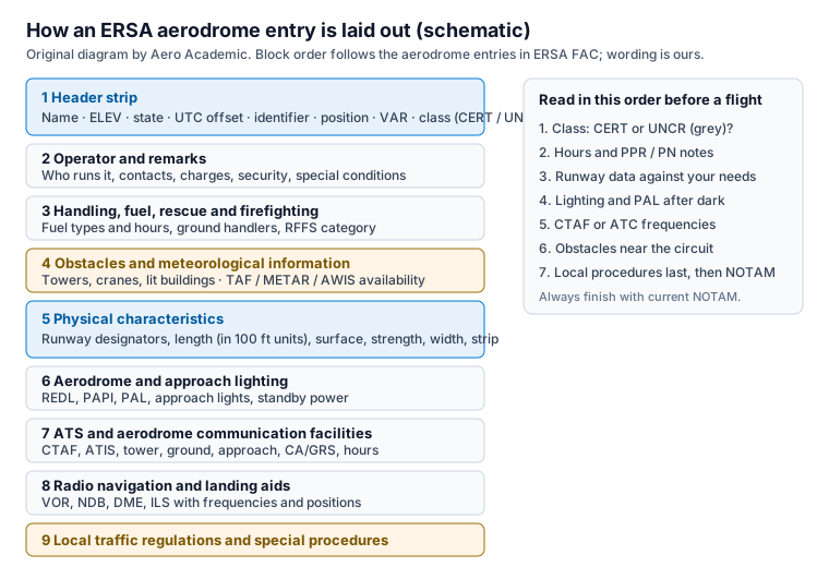
The header strip carries the aerodrome name, the elevation, the state, a UTC offset, the location identifier, the aerodrome reference point position, the magnetic variation and the classification code. The identifier is a three, four or five letter aeronautical code, and the legend notes that three-letter codes are not necessarily the same as the ones airlines use.
Elevation is in feet and is the elevation of the highest point of the landing area. Sea level is printed as 00 and a minus sign means below sea level. Magnetic variation is shown in whole degrees magnetic, rounded to the nearest degree, so a header that reads 2 DEG W means variation of two degrees west.
Local time in Australia falls into three standard time zones. Eastern Standard Time is UTC plus 10 hours, Central Standard Time is UTC plus 9.5 hours and Western Standard Time is UTC plus 8 hours. The legend adds that you must allow for daylight saving where it is in force. If you are converting an ERSA hour to local time, add the offset to UTC and then apply daylight saving if it applies in that state on that date.
Table 1 sets out the codes you will meet in the classification and hours lines. The hours code H24 means a continuous service, HJ is sunrise to sunset, and HN is sunset to sunrise. These are daylight-based, so the clock hours move through the year. Hours are shown in UTC unless the entry says otherwise.
Two codes are easy to swap. PPR means prior permission required, so you cannot just turn up. PN means prior notice required, so you must tell them first, but they are not approving the flight. When an exam stem uses both, read which one applies before you choose the response.
Runways are numbered from their magnetic direction rounded to the nearest 10 degrees. In an entry, a single runway is shown with the lower number first, parallel runways are listed centre, then left, then right, and multiple runways are shown in ascending order. Bearings are in degrees magnetic.
Table 2 summarises how length, surface, strength, slope and strip width are printed. The key habit is to read the surface code with its note. A surface coded C is always qualified by a note, and the note may say the strip is gravel, grass or something that changes your braking and drainage assumptions.
Pavement strength is expressed with the ICAO Aircraft Classification Rating and Pavement Classification Rating method. The legend adds that omitting a strength figure means the runway is unrated. Weight limits are printed as a mass with a tyre pressure, for example in kilograms and megapascals, and are gross limits: an aircraft may use the area only when it is below both figures at the time of operation.
Runway lighting is listed by short codes that tell you the type and intensity. In general, a REDL is a runway edge light, an RCLL is a centre line light and an RTZL is a touchdown zone light. High, medium and low intensity runway lights are shown as HIRL, MIRL and LIRL, with the legend noting how many stages of intensity each provides. Obstacle lights are described as high, medium or low intensity, with white flashing, red flashing or red steady displays.
The legend states that no standby power is available unless an entry says so, so look for the standby power note against the lighting line if you intend to arrive at night. Colours are abbreviated with single letters, and taxiway centre line lights are green and edge lights blue.
A precision approach path indicator, shown as PAPI, is a row of lights beside the runway. On the correct slope you see two red and two white. Above the slope you see more white, and well above it all white. Below the slope you see more red, and well below it all red. The ERSA legend also gives the minimum eye height over the threshold at which an on-slope indication will be seen, so a long-bodied aircraft may need to fly with the next light showing.
Pilot activated lighting, PAL, lets you turn on runway lighting by transmitting on the published frequency. The legend describes the activation sequences, and says non-standard sequences and audio acknowledgement responses are published for particular aerodromes in the ERSA directory. Read both the legend and the aerodrome entry before you rely on PAL for the first time.
An aerodrome frequency response unit, AFRU, replies automatically when you transmit on the aerodrome frequency, normally the CTAF. The legend explains that it helps you notice that you selected the wrong frequency. When an entry shows AFRU in the CTAF heading, a reply of the aerodrome identifier followed by CTAF confirms you are on the right frequency, and a low-volume tone burst means other transmissions were heard in the previous five minutes. Three clicks of the microphone within five seconds also make it respond.
Frequencies for operations at an aerodrome are listed against the location under the CTAF heading. The legend says that carrying a serviceable VHF radio, and being qualified to use it, is mandatory when operating at or near non-controlled certified and military aerodromes, and it describes the limited circumstances in which an aircraft without a working radio may operate. Read that wording in full before you use it.
For inbound traffic, the legend says to monitor and communicate on the designated CTAF from 10 miles to landing. Departing aircraft should do so from start-up, through taxi, until 10 miles from the airport unless local procedures say otherwise. A certified air/ground radio service is an information service, not an air traffic service: pilots keep full responsibility for deciding what to do.
Navigation aids are shown as the type, identifier and frequency, with the position. A VOR and DME at the same site are shown with the VOR frequency, because the DME is paired to it. Bearings and distances are from the aid to the aerodrome reference point, in degrees magnetic and nautical miles, unless the entry says to a runway threshold, and aid hours are H24 unless shown otherwise.
Suppose an entry header reads: elevation 99, state WA, UTC plus 8, identifier ending in JT, variation 2 DEG W and class CERT. You can say at once that the highest point of the landing area is 99 feet above mean sea level, local standard time is UTC plus 8, variation is two degrees west, and the aerodrome is certified, so a full NOTAM service applies.
Now suppose the lighting block shows runway 06L/24R with MIRL, PAL plus audio acknowledgement and a frequency, and a PAPI on runway 24R with a note that it is activated by PAL outside tower hours. Read in order: medium intensity runway lights with three stages, activated by transmissions on the published frequency when the tower is closed, with an audio acknowledgement reply. Your night plan should include the frequency and the activation steps, and your landing plan should account for the PAPI only after activation.
A final check is the hours line. If the tower hours end before your arrival, the airspace reverts to what the entry says. For the Jandakot entry, for example, the local procedures say the airspace becomes Class G outside tower hours, which changes your radio calls. The ATS entry and local procedures tell you what to do. That is the whole skill: slow, in-order reading, using the legend when you are unsure.
The ERSA Introduction legend defines the aerodrome and facility codes. General and meteorological abbreviations are defined in AIP GEN 2.2, and the legend says its general codes are based on that list.
PPR means prior permission required, so you must be given approval before you arrive. PN means prior notice required, so you must advise in advance. They are different obligations.
Runway length is shown in multiples of 100 feet, so a runway between 6,950 and 7,049 feet is printed as 70. Use declared distances and performance data for take-off and landing calculations.
On or close to the approach slope the two units nearest the runway show red and the two furthest show white. More white means above the slope and more red means below it.
An aerodrome frequency response unit is installed. It replies automatically to transmissions on the aerodrome frequency to help you notice that you selected the wrong frequency.
https://www.aeroacademic.com.au/guides/ersa-abbreviations-and-symbols-guide