 Aero Academic
Aero Academic
Aero Academic
Density altitude is the altitude in the standard atmosphere at which the air has the same density as the air you are in. Hot, high or humid conditions raise it, so the aircraft behaves as if the airfield were higher than it really is. It is pressure altitude corrected for temperature, and it governs take-off distance, climb rate and available power.
Checked against: Part 61 Manual of Standards (Compilation No. 6, registered 19/08/2026), Schedule 3 units CMTC (2.2) and COPC (2.1); AIP Australia Amendment 129 for standard atmosphere references.
| Case | Elevation, QNH, OAT | Pressure altitude | ISA temperature at that altitude | Density altitude |
|---|---|---|---|---|
| Standard day at sea level | 0 ft, 1013 hPa, 15 C | 0 ft | 15 C | 0 ft |
| Hot afternoon, inland field | 1,500 ft, 1003 hPa, 31 C | 1,800 ft | 11.4 C | about 4,150 ft |
| Hot day, elevated field | 3,000 ft, 1013 hPa, 35 C | 3,000 ft | 9 C | about 6,120 ft |
| Cold, high pressure morning | 0 ft, 1023 hPa, 5 C | about minus 300 ft | 15.6 C | about minus 1,570 ft |
| Effect | Why | What you notice |
|---|---|---|
| Longer take-off roll | Less lift per unit of true airspeed, so a higher true airspeed and groundspeed is needed for the same indicated airspeed | Runway used increases |
| Lower climb rate | Less excess power available and a lower propeller or rotor efficiency | Poorer gradient over obstacles |
| Less engine power | A naturally aspirated piston engine takes in less oxygen per stroke | Lower manifold pressure and power at full throttle |
| Reduced hover performance in helicopters | More power required and less available in thin air | Lower maximum hover and take-off weights |
| Higher true airspeed for a given indication | Indicated airspeed is based on dynamic pressure, which falls with density | Faster touchdown groundspeed |
Air density determines how much lift a wing or rotor makes, how much oxygen an engine breathes and how much thrust a propeller develops. Density altitude expresses density in a convenient unit: the altitude in the International Standard Atmosphere that has the same density as the actual air. If the density altitude at your airfield is 6,000 feet, the aircraft will perform as it would at 6,000 feet on a standard day.
Part 61 MOS Schedule 3 expects both the concept and the computation. The CPL meteorology unit includes listing the effect of changes in temperature, pressure and humidity on air density, and the operations, performance and planning unit includes determining density height from outside air temperature and pressure height, by density altitude chart, manual computer, flight manual chart or mathematics.
The International Standard Atmosphere is the reference. At mean sea level the standard temperature is 15 degrees Celsius and the standard pressure is 1013.25 hectopascals, and temperature falls by about 2 degrees Celsius for every 1,000 feet in the lower atmosphere. The MOS wording for setting the altimeter to the standard setting uses 1013.2 hPa, which is the same setting to the precision used in practice.
Density altitude therefore depends on two departures from standard: pressure, which sets the pressure altitude, and temperature, which corrects it. Humidity also matters, because moist air is less dense than dry air at the same temperature and pressure, so a humid day is slightly worse than the calculation shows.
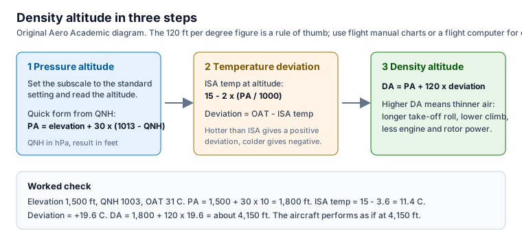
Pressure altitude is the altitude indicated when the altimeter subscale is set to the standard setting. You can get it directly by winding the subscale to the standard setting and reading the altimeter, which is what the MOS describes when it speaks of using cockpit temperature and an altimeter setting of 1013.2 hPa.
On the ground you can estimate it from the QNH. Each hectopascal of pressure is worth roughly 30 feet in the lower atmosphere, so pressure altitude is about the field elevation plus 30 times the amount by which 1013 exceeds the QNH. A QNH of 1003 on a field at 1,500 feet gives a pressure altitude near 1,800 feet. A QNH above 1013 gives a pressure altitude below elevation.
Find the standard temperature at your pressure altitude by taking 15 degrees and subtracting 2 degrees for each 1,000 feet. Subtract that from the actual outside air temperature to get the deviation. A positive deviation means warmer than standard, which thins the air.
Then add about 120 feet for each degree of deviation to the pressure altitude. That gives density altitude. The factor is an approximation that works well in the ranges used for training, and flight manual charts or a flight computer give the same answer to the accuracy that matters. Figure 1 shows the three steps and Table 1 gives four examples.
Check the first worked example against the figure. Elevation 1,500 feet and QNH 1003 give 1,800 feet pressure altitude. The standard temperature at 1,800 feet is 15 minus 3.6, which is 11.4 degrees. An outside air temperature of 31 degrees is a deviation of 19.6, which adds about 2,350 feet. The density altitude is therefore about 4,150 feet.
A higher density altitude makes the aeroplane perform as though the field were higher. A normally aspirated piston engine develops less power, the propeller makes less thrust, and the wing needs a higher true airspeed to produce the same lift. Because indicated airspeed is what you fly by, the aeroplane lifts off at the same indicated speed but a higher groundspeed, so the take-off roll is longer.
Climb performance falls for the same reasons, so the gradient over obstacles at the end of the runway is worse. Table 2 summarises the main effects. The practical consequence is that the performance figures you extract from the flight manual must be entered with the density altitude or with the temperature and pressure altitude the chart asks for. Using elevation alone on a hot day can understate the take-off distance badly.
Helicopters are more sensitive to density altitude because power is the limiting factor. In thin air, more power is needed to hover and less is available, so the maximum take-off and landing weight and the maximum hover height fall. A load that is comfortable at sea level on a cool morning can exceed what the helicopter can hover at a high elevation on a hot afternoon.
The flight manual gives hover and take-off performance charts that take density altitude or temperature and pressure altitude as entries. The sensible habit is to check the chart before you accept a load, not after you find the helicopter will not lift.
You plan a mid-afternoon departure from a field at 1,500 feet. The weather report gives QNH 1003 and a temperature of 31 degrees. From the first worked example the density altitude is about 4,150 feet, so you enter the take-off chart at that figure, not at 1,500 feet. The chart shows a longer ground roll and a lower climb gradient than the morning figures you looked at earlier.
You now have choices that cost nothing: leave some fuel or baggage behind, wait for a cooler part of the day, or use a longer runway. If the margin to the obstacle at the end of the runway is thinner than your personal minimum, the right answer is to change the plan. Doing the calculation before engine start is the habit that keeps a hot-day take-off from becoming a surprise.
The inputs are elevation, QNH or pressure altitude, and outside air temperature. Elevation comes from ERSA for the aerodrome, which gives the elevation of the highest point of the landing area in feet. QNH and temperature come from the weather report, automatic weather information service or ATIS. Our guides on reading a METAR and on ERSA show where each of those lives.
If you cannot get a QNH, set the subscale to the standard setting and read pressure altitude directly. Then use the temperature to correct it. Keep a note of the figure you used so you can show your working when you plan.
The most common mistakes are using field elevation instead of pressure altitude, applying the temperature correction with the wrong sign, and forgetting that colder than standard gives a density altitude lower than pressure altitude. A second group is using the rule of thumb outside the flight manual limits, or entering a performance chart with density altitude when the chart expects pressure altitude and temperature. Always read the chart legend to see what it wants.
A final trap is treating a calculated answer as exact. The factor of 120 feet per degree is an approximation. In an exam, answer to the precision of the method the question names, and in flight, use the flight manual and add margin.
It is the altitude in the International Standard Atmosphere at which the air has the same density as the actual air. It is pressure altitude corrected for temperature.
Find pressure altitude, subtract the standard temperature at that altitude from the outside air temperature to get the deviation, then add about 120 feet for each degree of deviation.
Yes. Moist air is less dense than dry air at the same temperature and pressure, so high humidity raises the effective density altitude slightly.
Yes. On a cold day with high pressure at a low elevation, pressure altitude and density altitude can both be below zero, which improves performance.
Thinner air produces less lift and thrust, so you need a higher true airspeed and groundspeed to lift off at the same indicated airspeed, and the engine makes less power.
https://www.aeroacademic.com.au/guides/density-altitude-and-aircraft-performance